Soil indicators for sustainable planning
Introduction
Soil provides numerous benefits through ecosystem services (ES), ranging from food provision over regulation of surface runoff to drug research and development, and has been cultivated over centuries. As such, it is a resource widely recognized as highly valuable – traditionally by disciplines closely working with soil such as agriculture but also increasingly by public discourse. Yet, soil is often marginalized as a two-dimensional surface in spatial planning, foregoing the importance of its third dimension: its quality.
Motivation
Soil quality is a feature hardly tangible due to its subsurface and invisible nature. Although various soil quality indicators exist, their specialization and orientation towards soil experts limit both practical applicability and communicative outreach. Moreover, the wide range of benefits soil provides is at the same time soil’s greatest strength and its greatest weakness: the multitude of benefits is what makes soil so precious a resource but it is also the reason why there is no single, objective soil quality indicator. In other words: comprehensive consideration of soil in spatial planning is stuck between conflicting, subjective use preferences.
Goal
Two soil quality indicators are developed. The first indicator, originally named BOKS (BOdenKonzept Stuttgart) adapts a tested and successfully applied approach from Germany to Swiss conditions. It is also used as a reference indicator to evaluate the performance of the second indicator. The second indicator, named SQUID (Soil QUality InDex) uses the ES concept to explicitly link soil to the benefits humans obtain from it. The idea is to combine relevant information on soil quality, information accessibility for both experts and non-experts, and effectivity for spatial development with the indicator’s ability to focus on “soil use” rather than on “soil potential”. This contributes to the overall goal of increasing communicative outreach of soil quality and facilitates the integration of soil into spatial development processes by fostering discussion among stakeholders about the various soil-derived benefits and their respective importance for any given project.
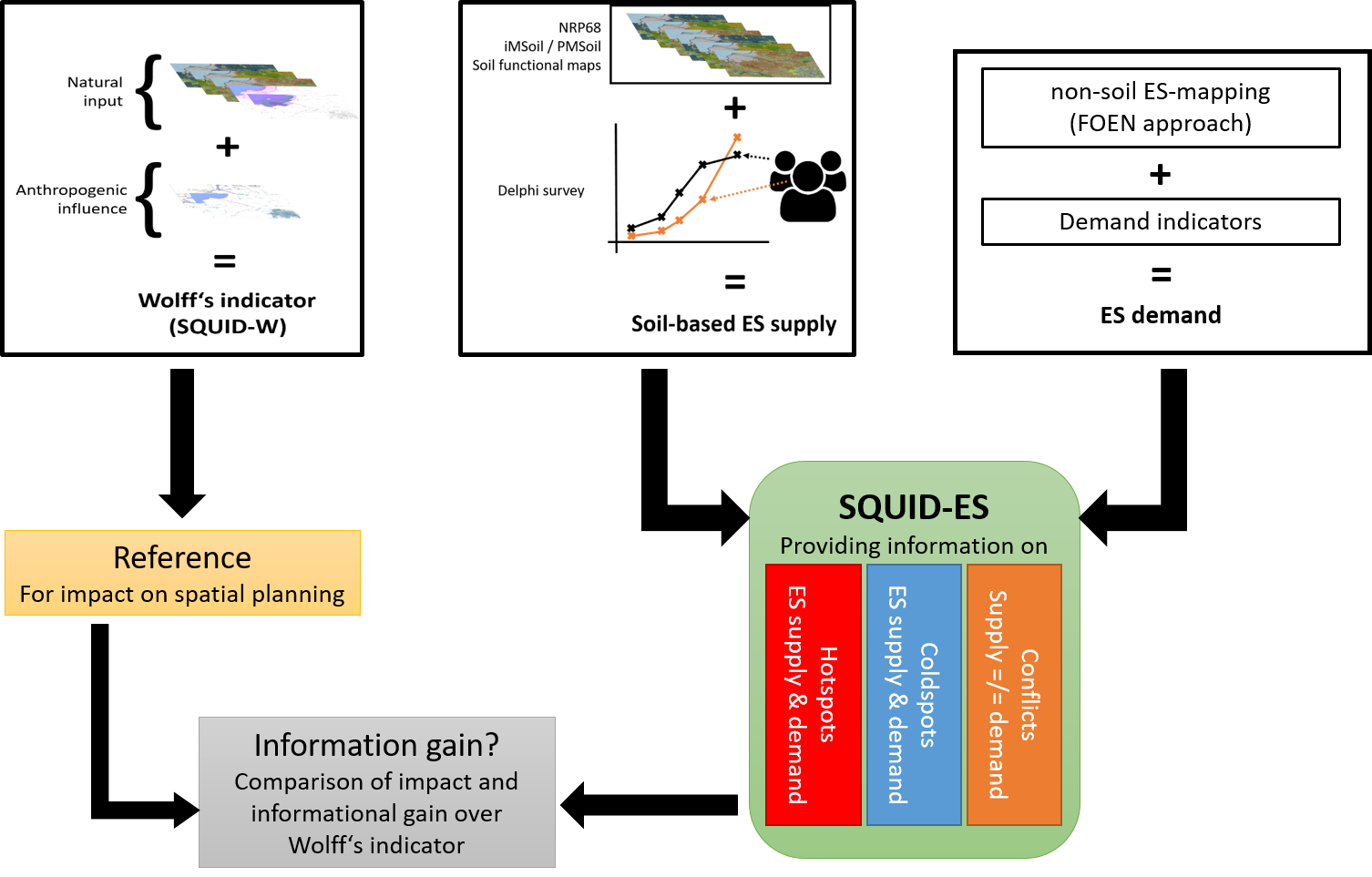
Approach
Both indicators are based on soil functional raster maps provided by Agroscope. All soil functional rasters feature a resolution of 20x20m and are derived from remote-sensing data. For the BOKS, we rely on the original approach and aggregate soil functional rasters, protected areas, and detrimental human impacts into a single soil quality index.
Assembly of the SQUID consists of two steps. First, soil functions are linked to ES provision using an expert-based Delphi survey, and soil-based ES provision is mapped. To achieve the best fit to Swiss conditions, the SQUID relies on the list of nationally important ES published by the Swiss Federal Office for the Environment (FOEN). Second, soil-based ES provision can be aggregated to a wide range of either focused indices (for example, focused on ES related to recreation or ES related to food provision, etc.) or a single overall soil quality index.
Expected results
This project develops two soil indicators capable to deliver relevant information for planning the sustainable use of soil, its functions, and its ES: BOKS and SQUID. While both indicators target strategic spatial planning, i.e., directive plans, the second ES-based indicator will also deliver useful information for land use planning at the municipal level by offering insights on ES supply and demand within municipal boundaries. SQUID especially is capable of pointing out hot and cold spots of soil-based ES provision and can accommodate various thematic foci to identify areas with potentially conflicting interests.
Duration
January 2017 – January 2018
Financing
Swiss National Science Foundation SNF
Part of the National Research Project NRP68 “Soil as a Resource”
Project Team
Prof. Dr. A. Grêt-Regamey, Planning of Landscapes and Urban Systems PLUS, ETH Zürich
Thomas Drobnik, Planning of Landscapes and Urban Systems PLUS, ETH Zürich
Lukas Bühlmann, VLP-ASPAN
Thomas Hersche, suissemelio
Hansruedi Diggelmann, Diggelmann Planung
Contact
Thomas Drobnik: